

Category Filter
La riba del puerto de Ciutadella: un paseo por su historia y patrimonio
Blog entreolas

La riba del puerto de Ciutadella: un paseo por su historia y patrimonio

Por Joan Carles Palos Nadal


puertoCiutadella


El puerto de Ciutadella se sitúa en el extremo de poniente de la isla de Menorca. Considerado desde la Edad Media como uno de los más bellos y emblemáticos del Mediterráneo, su entorno atesora un patrimonio histórico de gran importancia.


Su tráfico intenso de pasajeros y mercancías obligó en el 2011 a la construcción de un nuevo dique en Son Blanc, a las afueras del puerto, más grande y seguro. El puerto de Ciutadella es conocido también por el fenómeno de las rissagues o mareas del Pino, oscilaciones extraordinarias del mar por causas atmosféricas que pueden alcanzar o superar los dos metros de altura.
 

Castillo de Sant Nicolau

Este puede ser el inicio de un agradable y sencillo paseo que nos permita conectar con la historia y patrimonio de Ciutadella, capital de Menorca hasta el siglo XVIII, y su puerto. Una caminata tranquila que nos puede llevar menos de una hora.


El Castillo de Sant Nicolau está estratégicamente situado en la boca del puerto de Ciutadella. Esta torre de defensa costera fue construida por orden de los españoles, a finales del siglo XVIII, debido a los numerosos ataques por mar que en tiempos pasados sufría la isla. Tiene forma de pirámide truncada, con planta octogonal y está construida en marés (piedra extraída de las canteras de la isla). Un foso protege todo su perímetro y destaca por la belleza de las esculturas barrocas que adornan su fachada.


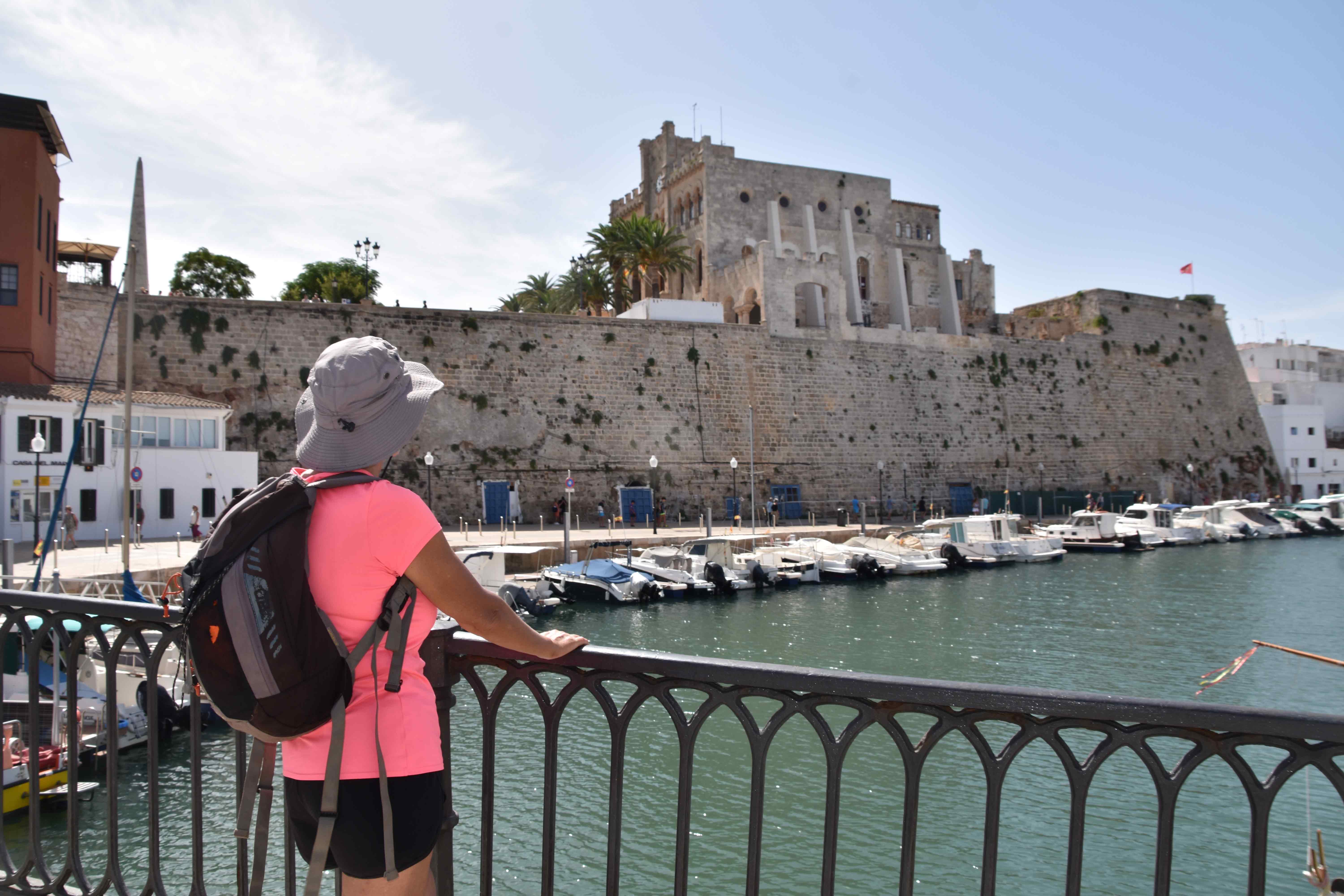
Muralla renacentista y edificio del Ayuntamiento desde el puerto de Ciutadella
 

Des de aquí, por el paseo de Sant Nicolau, nos dirigimos a la plaza del Born. Las fiestas de Sant Joan de Ciutadella concentran sobre su esplanada la mayoría de los actos que tienen relación con los caballos, como los populares caragols, donde los jinetes los hacen brincar al ritmo de la música, jaleados por el público.
 

Plaça des Born

El centro de la plaza está presidido por un obelisco que recuerda l’any de la desgràcia, cuando en 1558 la ciudad fue invadida, saqueada y prácticamente destruida por la armada turca. El monumento fue erigido en 1858 para conmemorar los 300 años de este trágico suceso.


Este emblemático rincón de la ciudad está rodeado por diversos palacios y edificios importantes del centro histórico de Ciutadella. De todos ellos cabe destacar dos, Torre Saura y Can Vivó Salort, ubicados uno frente al otro a la entrada del carrer Major des Born que conduce a la catedral gótica de Menorca.


Des de la plaza del Born bajamos al puerto por cualquiera de las callejuelas que conectan la parte alta de la ciudad con el mar. Un puente nos permite cambiar de orilla y disfrutar de una nueva perspectiva. El camino de Sa Farola nos aleja del ajetreo de la urbe y nos invita a respirar un ambiente más marinero, de pequeñas calas con sus tradicionales embarcaderos y embarcaciones de pesca.
 

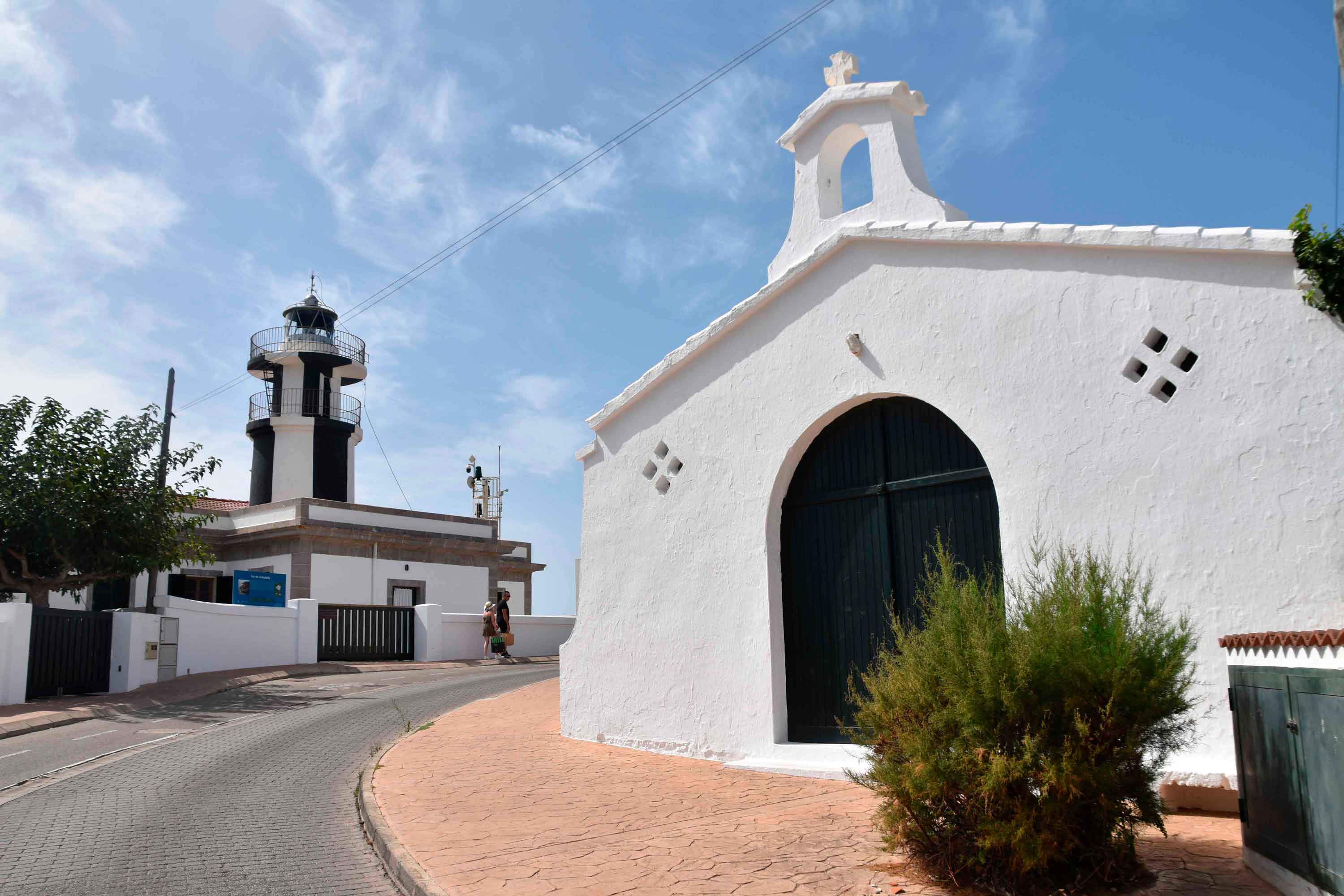
Sa Farola

El faro del puerto de Ciutadella, conocido como sa Farola, entró en servicio en 1863. Ubicado a 21 metros sobre el nivel del mar, desde sus acantilados se obtiene una perspectiva bella y conmovedora del entorno.


A su lado encontramos la capilla de Nuestra Señora de la Asunción, de 1950, levantada para que las familias residentes en aquella zona, pudieran acudir a misa. Desde principios del siglo XX, sa Farola se había convertido en una de las primeras zonas de veraneo de Menorca.


Faro del puerto de Ciutadella, sa Farola

Asset Publisher
Morocco's Mediterranean side
Guías de viajes

Morocco's Mediterranean side

  This region is perfect for exploring cities with centuries of history and switching off amid natural landscapes and unspoilt beaches. From Tangier to Nador, here are ten places in northern Morocco to discover by motorhome.   Only a few kilometres separate Spain from Morocco; in less than an hour by ferry from southern mainland Spain, an entire country opens up that is best discovered slowly. The Rif massif dominates this Amazigh region and has shaped a landscape of small, remarkable roads that cross valleys and hug the coastline.   1: The gateway to Morocco Tangier This city is a gateway not only to Morocco but to the African continent. Located at a strategic point on the Strait of Gibraltar, it has Phoenician and Roman roots. The streets of the medina reveal both the Arab past and present, while this architecture mingles with 20th-century buildings dating from the period when Tangier was under international administration. Spanish influence can also be seen, for example in the Cervantes Theatre.   Tangier's ceramics reflect the colour of the sea   2: Views over the Strait Cape Spartel Cape Spartel, ten kilometres from Tangier, offers one of the finest views over the Strait. This is where the Atlantic gives way to the Mediterranean. The lighthouse here was one of the first in the country and has been operating since 1864. It stands within a nature reserve that fills up at weekends with Tangier residents looking to escape the city for a family day out. Nearby are also the Caves of Hercules and the Atlantic beaches of Sidi Kacem and Achakkar where surfing and other water sports can be enjoyed.     3: The Atlantic coast Assilah The narrow white streets of Assilah have become an open-air museum. Murals bring colour to the medina of this small Atlantic town. From the old-city walls you can see the ocean and the town's sandy beaches. It is the perfect place to stop and enjoy some fish.   Assilah's medina is recognised by UNESCO as historic heritage   4: The blue city Chefchaouen Morocco's blue pearl wins over travellers with its maze of lanes on the side of a mountain. The old town is a seemingly endless network of irregular streets lined with small shops selling souvenirs, clothes, food and spices. It is one of the best places to stay overnight and also a great base for enjoying the many walking trails in the region.     5: Switch off in nature Talassemtane National Park This natural park of almost 60,000 hectares is one of the treasures of the Rif Mountains. One of the best places to base yourself is the small village of Akchour, from where several routes set out into this mountainous area on foot or by bike. You can also see Atlas cedar forests and the waterfall named after the village.   Streams and natural pools abound in Talassemtane     6: The White Dove Tetouan Back on the Mediterranean, Tetouan is an essential stop. Its buildings are white, while in the medina this colour mixes with the green of many doorways. The old town is listed as a UNESCO World Heritage Site. Tetouan is also known as “the daughter of Granada” because of its Hispano-Moorish architecture. A few kilometres away lies Martil beach, the closest coastal area to the city and a good place to spend the night.   7: Sea and mountains Al Hoceima National Park Following the coastal road from Oued Laou towards Al Hoceima brings you to this national park, a vast landscape of nature and mountains that descend towards the Mediterranean. Between the cliffs and rocky stretches are small hidden beaches and coves such as Taoussarte and Taydiwine. Ospreys can also be seen hunting over these waters.   8: Mediterranean beaches Oued Laou Set between the mountains, the beach and small fishing village of Oued Laou are among the best places to stop, unwind and take a break from the journey. The road from Tetouan is one of the most beautiful in northern Morocco, following the coastline past cliffs and small rocky coves. Several campsites, shops and restaurants can be found near the village.   Green is associated with Paradise in Islam   9: The city on the cliff Al Hoceima This Rif city lies on the coast, surrounded by beaches and home to one of the most important ports in northern Morocco. It stands on an impressive cliff. Between 1994 and 2004, two major earthquakes struck the area, causing more than 500 deaths. It was also one of the centres of resistance to Spanish colonisation. Today, it is one of the most popular places for locals and travellers to spend their summer holidays and enjoy the calm Mediterranean waters.   10: The eastern coast Nador Nador is the final stop and the most important city on Morocco's eastern coast, only a few kilometres from Melilla. The city overlooks the Mar Chica, a saltwater lagoon connected to the sea. Following the road east, you come to the well-known Red Beach, a rocky beach, and the long Ras El-Ma beach, with several kilometres of sand. Close to the Algerian border lies the resort town of Saïdia, where you will find numerous large hotels and restaurants. 


Read more
Mallorca on foot and on two wheels
Guías de viajes

Mallorca on foot and on two wheels

  Mallorca's mild climate and good transport connections have led many walkers and, above all, cyclists to choose the island for their favourite sport. Here are ten routes to get your legs moving, either on foot or without leaving the saddle.   With 1,600 km of secondary roads and 468 km of signposted routes, Mallorca offers the perfect infrastructure for cycle tourism. Its diverse landscape —coastal, urban, rural and mountainous— also makes it ideal for exploring on foot. The experience is even better when the island is quieter, between October and May. 1: Contrasting landscapes along the old railway line The Manacor–Artà greenway This is not a circular route, so you will need to plan the return journey. At just under 30 kilometres, it is relatively easy and lets you enjoy a variety of landscapes without getting off the bike, following the old railway line. Starting east of Manacor, by the time you reach Artà you will have passed through tunnels and old stations and seen rural Mallorca, mountains, Mediterranean woodland and, in the distance, the coastline of s'Illot and Cala Millor. An easier alternative runs from Son Carrió to Son Servera.   2: Culture and the Serra de Tramuntana Valldemossa, Deià and Sóller The Valldemossa Charterhouse, where Chopin stayed, and Sóller's architectural heritage, particularly its Modernist buildings, make these two Serra villages well worth visiting. This road-bike route is for experienced cyclists. From Valldemossa, head to the Monastery of Miramar, founded by Ramon Llull, and Son Marroig, associated with Archduke Ludwig Salvator of Austria. Following the coast, you will reach Deià before descending to Sóller's Orange Valley. The route covers 36 km. 3: Mallorca's highest point, Lluc and the Cúber and Gorg Blau reservoirs Puig Major from Sóller Another demanding route for experienced cyclists, but one that belongs in this top ten because it climbs the island's highest peak. From Sóller, climb to the Monnàber tunnel, around 900 metres long. Roughly 2 km farther on is the military base, where permission must be requested to access Puig Major. From its 1,445-metre summit, you can enjoy some of the island's finest views. Afterwards, descend towards the Lluc Sanctuary, another essential stop, passing the Cúber and Gorg Blau reservoirs. From Coll de Sa Batalla, return to Sóller along the MA-10.   Walking among ancient stones 4: Beaches and natural parks by bike From Cala Egos to Es Trenc This non-circular road-bike route covers around 60 km. It takes in the coast of Santanyí and Campos and some of Mallorca's finest beaches. Starting in Cala Egos, head to Portopetro via Camí des Barranc, passing along the northern edge of Mondragó Natural Park. Continue alongside the torrent d'en Reieta to Santanyí, then cross this attractive town and ride on to Es Llombards, Ses Salines and Colònia de Sant Jordi. There you can leave the bike and, if the weather allows, walk for a while and take a dip in Es Trenc-Salobrar Natural Park or, at the other end, Es Carbó. All are spectacular beaches. 5: Great views of the Serra and the coast Planícia from Esporles This 30 km mountain-bike route is of moderate difficulty. Starting in Esporles, one of the Serra's prettiest villages, head towards Mirador de Mar along the old path that once linked the village with Port de Calonge. The views are spectacular. Return towards the MA-10 to descend towards Banyalbufar, but turn off first towards Planícia. Depending on your energy and available time, you can explore one of the three routes within this public estate. On the return journey, stop at the Es Verger viewpoint before continuing to another beautiful village, Banyalbufar, and from there back to Esporles. 6: Phoenician necropolis beside the beach Son Real The walk through the public estate of Son Real, in the municipality of Santa Margalida, is especially suitable for families. It is only around 2 km long, with no significant climbs or descents, and includes plenty to interest children. There are four possible routes, but the essential one leads to the impressive Punta des Fenicis necropolis, with burials dating from the Iron Age through to Roman times. And while you are there, you can enjoy a swim at the beach next to it.   Sea and mountains in Sóller   7: Family walking and cycling S'Albufera S'Albufera de Mallorca Natural Park, in the north of the island, is ideal for families. There are four routes that can be completed on foot or by bike: Sa Roca, Es Colombars, Es Cibollars and Es Camí d'Enmig-Ses Puntes. The longest, around three hours, is the last of these, but all of them offer the chance to enjoy the park's rich wildlife, particularly its birdlife.   8: One of Mallorca's most photographed horizons Torrent de Pareis There are several routes, some even suitable only for mountaineers, leading to the spectacular mouth of this torrent, one of Mallorca's most photogenic beaches. The classic route is the descent through the gorge from s'Entreforc, where the Gorg Blau reservoir flows out: it takes around 6 hours, covers 5 km and requires experience or a good guide. The easiest family-friendly option is the path beginning at Sa Calobra beach.   9: Ramon Llull's place of contemplation Cura Sanctuary If Ramon Llull chose this as a place for spiritual retreat, there must have been a reason. Our suggested route starts in the village of Randa before climbing to Cura Sanctuary, where the Mallorcan philosopher withdrew in the 13th century and founded his school. Along the way, as well as enjoying impressive views, you will visit the Sant Honorat hermitage and Nostra Senyora de Gràcia Sanctuary. On the final section, along Camí de Bon Pastor, you can see some galleries that were used as ammunition stores during the Spanish Civil War. The only real difficulty is the access to Puig de Son Reus. 10: Refuge for Trappist monks during the French Revolution La Trapa Several paths lead to La Trapa, a monastery founded in 1810 by French Trappist monks who, twenty years after the storming of the Bastille, decided to flee the country. Abandoned only a few years later, the estate was acquired in 1980 by the environmental group GOB to prevent development. The most popular route to La Trapa begins at s'Arracó cemetery. Another route from Sant Elm follows the coastline. A third goes via Coll de Sa Gramola and is a good choice when the rocks are wet. All of them provide exceptional views of the Sa Dragonera islet.   Horses accompany cycle tourists


Read more